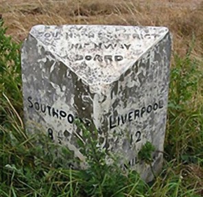
Old Formby Milestones

Reg Yorke – August 2006
Two interesting old Milestones survive, marking the original main road through Formby in the period prior to the construction of the Formby By-pass in the 1930’s. These stand one mile apart; one just south of the actual Formby boundary on the left of the road (B5424), entering Formby. The other stands on the left of Church Road, near its junction with Davenham Road. This was until very recently obscured by a garden hedge, now removed. These two stones of similar shape and size were placed by The Southport Highway Board in the 19th Century and give the distances to Liverpool and Southport. The southernmost is the best preserved and can easily be read. The one in Church Road has become more worn and the lower parts difficult to read.
The Southport District Highway Board appears to have been created in the mid 19th Century following the General Highways Act of 1835, which empowered “any parish of more than 5,000 inhabitants to set up a Highway Board”. A further Act in 1862 authorized the Justices of the Peace to set up highway boards compulsorily by the combination of parishes. North Meols was one of the few parishes to adopt the suggestion.
According to Bailey’s History of Southport, when the General Highway Act was passed in 1835, the total number of such Highway Boards in the whole of England and Wales were very few. They were abolished by the Local Government Act of 1894, when civil Parish Councils were first created. Formby Parish Council then came under the Rural District of West Lancashire, based on Ormskirk In 1905 the Formby Urban District Council was formed and came under the Lancashire County Council formed in 1888.
